Copper Falls State Park, WI
On Monday, after dropping off our U-Haul in Hurley, we headed south and west to Copper Falls State Park.
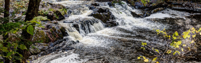
We found a great site just above the Bad River, ate lunch, napped, and headed out for the “signature hike” of the park — a 2.5 mile hike that included views of the Copper Falls and Brownstone Falls and a spur hike up to an observation tower. The tower gave us a good view of the area, but too many of the trees near the tower were too high and blocked the view.
David found enough wood for a fire so we grilled green beans, rib steak, potatoes and onions, and sweet potatoes. A salad added to make a great dinner.
On Tuesday we took the second hike within the park — to Red Granite Falls (2.5 miles). After the hike, we drove up to Ashland, WI (about 25 miles), ate lunch on the shore of Lake Superior, and then looked around the town. We would like to return to this area and in particular would like to take the ferry to Madeline Island.
Dinner back at Copper Falls was chicken breast, a melange of parsnips, potatoes, and onions, plus a salad.
Before leaving the park on Wednesday morning, we returned to the “signature hike” so that we could see it in a different light. Then it was off to our next campground.
Copper Falls State Park CG Review: This state park has two campgrounds; we visited only the north one. The north CG has approximately 33 sites, most with electric. Sites are well-separated, but not entirely private. Amenities include pit toilets, water hydrants, a dump, great hiking trails, and fire rings. Firewood is available for purchase. No AT&T service in the park and no TV and no electric. We got limited AT&T service a short drive from the park.
-- Janet (text) and David (photos)
Recent Comments