Cabot Trail
It took us seven hours to drive what should have been a less than 2 hour trip on the Cabot trail. We were moving from the Cheticamp campground on the west coast to the Broad Cove Campground on the east coast of Cape Breton Highlands NP. But we kept stopping and exploring hiking trails.
We made multiple stops at lookouts and tried a few trails. As we approached French Mountain (455 m) we were able to look south along the coast and saw the Corney Brook Campground which is right on the beach of the Gulf of St. Lawrence. It’s a primitive campground with no reservations but an idyllic site.
Soon we pulled off to the Bog Trail. A short 1/2 mile trail through a large bog area with a boardwalk to protect the plants. There was an abundance of pitcher plants, Canadian burnet and cotton grass. Some golden heath. Away from the bog along the roadside there was lots of cichorieae.
Our next stop was the Fishing Cove overlook. One can walk five miles down to the cove where there was a former community of Scots who lived there making a living fishing — they even had a lobster factory. We didn’t.
Next walk was a mile round trip along the MacIntosh Brook to a lovely waterfall. Lots of young people climbing the falls. The highlight of the trip was not the waterfall, but the hardwood forest — mostly beech, birch, and maple. Many of the beech were affected by some sort of canker that made their bark very interesting. David has become obsessed with the different patterns he sees in the bark of the trees along our walking trails. His stopping for pictures makes us the slowest hikers on the trail.
It was just a short drive to the Lone Shieling trail. A shieling is a Scottish crofters home. In 1934 1000 acres of land was donated by an immigrant from the Isle of Skye to the Canadian government with the agreement that the maple trees on the land would be preserved and a model of a Scottish Farm home would be built. In 1936 this land became part of the newly established Cape Breton Highlands NP. 80% of Nova Scotia’s old-growth trees are located in the valley — we were walking through just a small part of it. The rest of it is a protected area with no hiking or camping permitted. The sugar maples are reported to be 350 years old. The undergrowth is mostly small maple seedlings waiting for the larger ones to die so they will get more light and can prosper.
The road began to climb (12% grade) until we were atop the Highland plateau. We could look down into the Mackenzie River. At the very top of the plateau the land looks like Alaskan tundra with stunted spruce — no more hardwoods. From there we began our descent (13%). Nearer to sea level we stopped at the Cabot Trail Food Market. We needed a half-gallon of milk and figured they would carry it, but were totally surprised by all that they carried. It was part grocery, part liquor store, part hardware store. Since it’s the only store for miles around, it makes sense. And, the prices weren’t bad either.
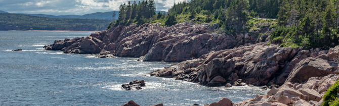
As we turned south along the Atlantic coast of Cape Breton we began to have ocean views reminiscent of Maine. Tomorrow we will explore the coast some more.
We drove a few miles past our campground to stop at Rod’s Fish and Lobster market, but found it closed for the season. We headed back to the FreshMart and asked about fish. The owner said there really isn’t any place to buy fish in Ingonish. A bit surprising as the ocean is right there. We will have to look into this a little further.
We checked into Broad Cove CG. Our site for tonight is at the end of a row with views of the trees. Unfortunately, the sites are lined up parking lot style. An older section of the CG, where there is no electric, is much more inviting with sites in among the trees.
-- Janet (text) and David (photos)
Recent Comments