Osprey Trail
Cote-a-Fabien campground, the location of the trailhead for the Osprey Trail, is less than a 1/2 mile from our campsite, but is on the other side of the Kouchibouguac River. But, because there is no nearby bridge across the river, we had to drive 20 miles (30 minutes) along the river on one side and up the other. On the way we stopped at the foot/bicycle bridge that crosses the bridge closer to our campground. Nice view from the bridge.
Bicycling is very popular here. There are smooth, gravel trails throughout the park. Biking is advertised as a 365 day/year activity. They even rent bikes with fat tires for snow covered trails.
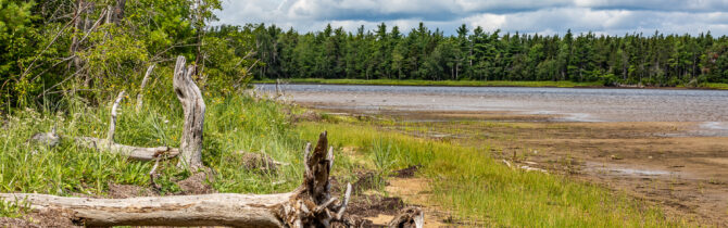
The Osprey Trail was a lovely “lollipop “ trail that paralleled the shore of the Kouchibouguac Lagoon at the mouth of the river then crossed over a spit of land so we were walking along the Black River. We walked out to Black River point from where we could look over to the North Kouchibouguac dunes and the other side of the Black River and watch sandpipers on the low-tide beach.
The trail had been touted as one to see Osprey and bald eagles diving for fish. As nice a trail as it was, we saw not one. We did see plenty of scat filled with blueberries (bushes lined the trail) which was either from a raccoon or a bear. I would assume the former though the latter are supposed to be here.
As we finished the last leg of our hike, a light fog began to move in and there was light rain. By the time we got back to our van it began to rain in Ernest — but’s soon stopped.
When we returned to our campsite we were disturbed to find that our power cord, door mat, leveling blocks, and unopened bag of wood had been stolen. This is the first time that we have ever had anything taken when we have left a monitored campsite for a hike. Makes me sad that someone would do that. The warden came to take a report, but I doubt anything will come of it.
-- Janet (text) and David (photos)
Recent Comments