Joshua Tree National Park
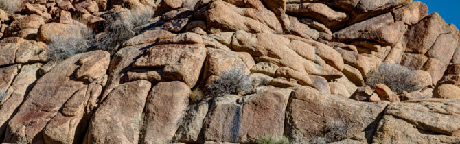
We started our day at Joshua Tree National Monument with a 1.8 mile walk through, around, and over some of the rock piles near the Cottonwood Campground. David’s pictures will show you how amazing these split and weathered granite rocks are. We definitely have to come back to this NP sometime.There is a great deal of hiking we would like to do. Plus, because we needed to get to the San Diego area to meet up with Amanda, we never even went to the north side of the park to see a Joshua Tree.
After leaving the national park, we headed down toward the Salton Sea. We first passed a very interesting canyon with highly eroded rocks — reminiscent of the painted desert. Near Mecca, CA we began to see the Salton Sea in the distance.
We were surprised to learn that the Salton Sea was formed in 1905 when water from the Colorado was accidentally dumped (for two years ago) from an aqueduct onto an old sea bed on the desert floor. Until recently the evaporation has about equaled the input, but it is expected that with some new water use regulations, the sea will begin to shrink over the next six years.
Around the sea there is a fair amount of agriculture,; in particular, large fields of artichokes and peppers.There are also rows of palms being grown — perhaps date palms? After heading west from the Salton Sea, we passed trough some of the most arid, unvegetated land we have seen. It was a pleasure when we finally reached the mountains we could see in the distance. Route 78 through the mountains and Route 79 south took us through an area with real trees, something we haven’t seen in a while — pines, cedar, and even a few sycamores.
We found a campsite at Cuyamaca Rancho State Park. There were lots of places to camp, but it took a while to find a reasonably level site. Our site is very secluded and has a great view of the mountain on the opposite side of the road.
-- Janet (text) and David (photos)
Recent Comments