Lostine to Lowell ID
Incredible gorgeous drive today. We went up the side of one mountain, then down the other, then up another – ranging from 3500 to 5800 feet.
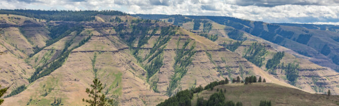
At the Joseph Canyon overlook we learned about the Nez Perce Indians and how they had been starved by the US soldiers when they destroyed their stores of Cannes root at a cave nearby.
The next canyon was the Buford Creek canyon. The creek flowed into the Grand Ronde River. Lots of water here.
At Lewiston we joined the Snake River. The Snake travels south from Jackson Hole, then north through parts of Idaho until at Lewiston (on the Washington Idaho Border) it mostly travels westward to the Columbia.
At Lewiston we joined the Clearwater River. At this point we were at about 600 feet and the temperature which had been in the upper fifties for most of the day was 77. The road follows the winding path of the river which soon changed from the Clearwater to the Lochse. The speed limit is 55 miles per hour, but David found it was about right to drive 45 to 25 on the curves.
Just past Lowell we found a NFS CG right on the river — Apgar CG, 7 sites. Plenty of room when we arrived, but it did fill up. We chose site 4 as it had a sandy beach. We enjoyed sitting on the edge of the Lochse River thinking about Louie and wondering if he would enjoy the river, and then returned to the van for a dinner of artichoke, hamburgers, and salad.
-- Janet (text) and David (photos)
Recent Comments