Idaho to Bozeman MT
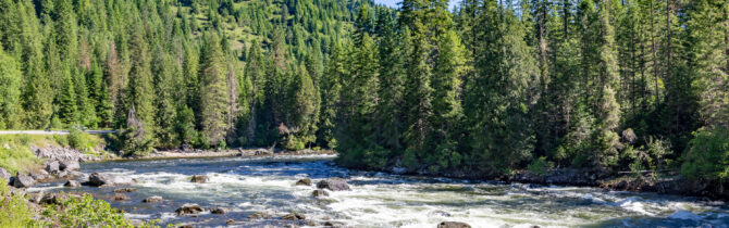
From our Apgar CG site we continued along Route 12 next to the river. For most of the beginning of the trip the Seaway-bitterroot wilderness was on the other side of the river and a steep hill was to the left of the road. Although the river looked perfect for whitewater rafting, we saw just one pair of kayakers and they were taking a break on the side of the road.
There are wooden footbridges for hikers to cross the river and backpack in the wilderness.
As we did yesterday, we saw many motorcyclists on this winding road.
The road was a steady climb with little change in scenery — evergreens across the river and cliffs to the left side of the road. No dispersed sites or campgrounds until 2300 feet. Probably because distance between river and cliff in the north doesn’t accommodate more than a two lane road.
This is called the Clearwater route — named for the river as it joined the Snake at Lewiston, but the river seemed to change names as we climbed. We left the river to begin a steep climb into Montana, crossing at a pass at 5200 feet. At the pass was an information center with a short walk through the woods behind it.
Along the road in Montana were white markers to show where people had been killed on this steep, winding road.
Soon we saw an area that had been recently burned by fire, then snow capped mountains on the edges of huge green fields of alfalfa and hay with many cattle grazing in the non+cultivated fields.
When we reached Missoula, even though it is at a higher elevation, it was very hot – 89-degrees. The whole country seems to be sweltering. We can put away our winter clothes for the remainder of our journey.
At Missoula we picked up I-90 and started East in earnest.
A fast drive over the mountains took us to Bozeman where we spent the night at the local Walmart Super Center along with about 40 or so other RVs, many of which look as if they spend more than one night here.
-- Janet (text) and David (photos)
Recent Comments