Hell’s Canyon Dam hike
In the morning it was still raining, and the cold front that had brought the rain had also brought cool air and calm winds. The water was a mirror — perfect for paddle boarding if Amanda had been with us.
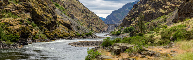
The rain soon stopped and we drove to the Hell’s Canyon dam. We learned that the dam when operating at full capacity provides nearly 2/3 of the electricity for Idaho. The dam was built over an 8 year period. It took nearly two years just to build the access road to the site and the diversionary tunnel for the Snake River.
The interpretive center was closed but we still were able to walk down to the river on the low side of the dam and walk a great ~2-mile hike along the side of the river. It was a bit dicey at some points as the side of the trail fell away steeply to the river far below. Also the path across many of the slides had many loose rocks. David stepped too close to the edge of the trail at one point and started to slide down the hillside. Fortunately he managed to grab a large clump of grass and pulled himself back to safety.
While on the walk we watched some day trippers rafting and boating down the river with outfitters. The great part of this hike was being able to see the river as it was before the dam was built.
Following our hike we left the reservoir behind and headed back on 86 to National Forest Riad 39 which will take us north through multiple national forests. We stopped for the night at Lake Fork nFS campground. A secluded camping area on the bank of Lake Fork Creek. No one else is here and the fee is $3.00. I would normally call this a quiet camp, but the rush of the creek belies that.
On our way to this site, we did see one other place we considered. About 3 miles south of here is a rest area where a large dispersed site (free) has been created behind it. Again the sites are located along the creek.
-- Janet (text) and David (photos)
Recent Comments