East of Zion
Today our plan included driving east through the park, traveling through the 1.1 mile tunnel built in the 30s, climbing to the Canyon Overlook, and exploring east and south of Zion NP before looping back through Springdale.
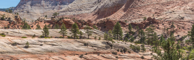
The drive east on Route 9 takes you through more stunning territory. At every turn of the road you want to stop to gaze and take pictures. When we reached the tunnel, the ranger arranged for westbound traffic to pause so we could go through in the middle of the tunnel. Ordinarily a Sprinter fits in the tunnel fine, but we have a number of antennas that increase our height to near the 11’4″ limit and she didn’t want to take any chances. These stoppages happen all day long for RVs and busses as the tunnel was not built to accommodate today’s larger vehicles.
We managed to find a parking place for the Canyon Overlook hike. As one of the guide books said, this is the hardest part of the hike. It was an easy hike even with a few hundred feet of elevation change which led to a spectacular view of Pine Canyon and Zion Canyon beyond. Many of the important landmarks of the park are laid out in front of you.
As we continued east, we saw a number of Desert Bighorn Sheep, including one male who was surveying the valley from a tiny tower. After admiring Checkerboard Mesa we left the park.
After turning south on Route 89 we headed down to Coral Pink Sands State Park. This park is a favorite of ATV enthusiasts, but has a nice, though hot, walk through the pink sands. The large drifts are made up of sand weathered away from the Navajo sandstone and deposited in this location because of the way the wind blows through a notch between two mountain. A lovely place though Janet would judge the sands to be salmon pink, not coral.
The remainer of the drive back to the west entrance of Zion was pleasant, but not particularly noteworthy.
The temperature at the van was 103-degrees when we returned.
-- Janet (text) and David (photos)
Recent Comments