Savoy Mountain State Forest
We took a short drive across 90 and north on 91 to the Mohawk Trail (aka Route 2). Our destination was the Savoy Mountain State Forest campground where we hoped to spend four nights before heading home. The forest has many attractive hiking trails and is near to other sights in the north-west corner of Massachusetts that we would like to see.
I (Janet) was particularly interested in driving the Mohawk trail once again as it was a regular part of my visit to see my grandmother Grace in the summer when I was young. During those summer visits there was always at least one trip over the mountains to North Adams to visit Aunt Leone and often we would go on to Troy NY to see Aunt Ora. Along the trail are so many of the sights I remember: the Long View Gift Shop (now closed), Florida Mountain with the Whitcomb Summit (my grandmother was born up on the mountain on her father’s potato farm), the hairpin turn with a gift shop/restaurant (now relocated behind a large rock to defend it from run-a-way trucks coming down the mountain).
Immediately after arriving and securing a site, we took a couple mile walk along the South Pond Loop Trail. A pleasant way to work out the kinks after our drive.
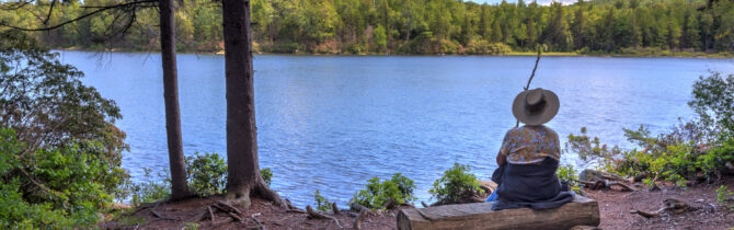
Our Wednesday hike was fantastic; we took the Busby trail (1.5 miles) to the Spruce Hill summit with its view of Adams, North Adams, and Mt Greylock, then returned via the Long Pond Trail, Blackburnian Loop, and Old Florida Road (2.2 miles). Except for some wet, mucky areas the trails were clear, well-marked, and easy. The trail was a gradual rise to the summit, except for the last 1/4 mile which was very steep with some rock steps (fortunately). The summit was spectacular and a great place for lunch. We suspect that this trail was built by the CCC when they were reforesting in this area in the 1930s.
Savoy Mountain Forest Campground review: The campground is located in an old apple orchard. There are a few sites in the grassy middle, but the majority of sites are nestled into the trees around the edge of the campground. The edge sites are mostly small and only a few are really level. This is certainly a campground meant for tents — bigger rigs would not be comfortable in any but a few of the sites. Each site has a picnic table and fire ring. The bathroom is clean and has hot water and a dishwashing station. There is a dump station. Nearly all sites are reservable so one can spend one night in any open site, but must go on reserveamerica.com to sign up for future nights. This is not a problem at this time of the year, but I suspect in the summer it would be necessary to make reservations for your entire stay before coming — at least 24 hours ahead. Our AT&T phones/data worked well.
[photonav url=’http://davidelmore.com/djv/wp-content/gallery/de1606/DE16064914-Pano-Busby_Trail-Massachusetts-Mount_Greylock-North_Adams-panorama-Savoy_Mountain_State_Park-Spruce_Hill.jpg’ mode=drag label=1]
-- Janet (text) and David (photos)
Recent Comments