Edmonton
Today we traveled Route 16 from west of Edmonton to east of Edmonton. The road, except for brief times when towns are near the road, is a wide four-lane divided highway with at-grade road crossings.
The adjective to describe the terrain today is “flat,” but there is variation from flat, unused fields with plenty of spruce and pine, to flat fields with cows and horses grazing, to flat fields a glow with canola in flower, to flat fields of wheat nearing harvest, and flat fields of alfalfa hay studded with large round bales waiting to be moved away. Along the way there were small towns such as Wildwood: The Bingo Capital of Canada. Vegreville: The home of the world’s largest Pysanka. Lloydminster: Advertising a ski school with a t-bar – I assume they are skiing into a valley as I saw nothing resembling a hill or mountain on the horizon. Elk Island National Park: With a herd of bison.
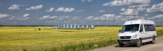
Edmonton must have some beautiful areas, but we certainly didn’t see them passing through on Route 16. We saw heavy industry, light industry, oil refineries, traffic lights, and the largest grain silos and loading facilities we have ever seen. The central business area of the city could be seen far to the south – a number of high-rise buildings like most cities. At one point we passed a mall which had signs for the usual mall stores. We passed Wayne Gretzky Drive.
At Lloydminster we crossed from Alberta into Saskatchewan. If anything, we were now in flatter country. I was reminded of driving US 24 across central Illinois. The difference is that in Illinois there is mostly corn, soy beans, and hay; here we see canola, wheat, and hay, with the added attraction of large black storage tanks for oil dotting the fields. Every field has oil being pumped from beneath it. The tanks are spaced across the farmed fields just as the windmills are spaced across the fields in the Midwest.
There are not as many campgrounds along here. We stopped for the night at the municipal campground in North Blackford. We had a site right on the edge of the campground so we had a view out to the west with no neighbors. Nice sunset. Dinner was a homemade sausage-vegetable soup and salad.
David Liard Municipal Campground: 70ish sites on a field with lots of trees throughout. Many have electric and water and a few have sewers. About 1/3 have no hook-ups. Raised hibachi-type grills (wheelbarrow of wood for $5) and picnic tables at most sites (ours had no table). Flush toilets and showers. RV dump. The entire facility is nice, but a little rundown. (We were told that a new management had just taken over, so perhaps changes will occur.) The campground advertises more than it delivers. For example, there is actually no wi-fi, the children’s playground is one climbing structure, and the “stocked trout pond” we didn’t see it until the way out. Fee: $17
-- Janet (text) and David (photos)
Recent Comments