Dawson Creek
Today we arrived in Dawson Creek. The end (or beginning) of the Alaska Highway (AlCan). We have driven the entire 1390 miles except for 97 miles between Haines Junction and the junction of the AlCan with the North Klondike Road. At times it has had gravel breaks and potholes and jolting frost heaves, but mostly it has been a decent paved road. Mostly better than some of the main roads in our home town.
Often today the roadsides were a sea of magenta from the fireweed which is in full bloom. The road itself was very busy especially as we came through Fort St. John. There the gas and oil industries are booming. Fort St. John has dubbed itself “The Energetic City.” There are tank trucks and pickup trucks everywhere. Flat bed trucks are hauling heavy equipment and prefabricated “hotels” for the workers. In the town most of the businesses are support services for the industry – brake shops, tire shops, drilling supply shops, transmission repair shops, etc. It was a bit like Williston, ND where we had passed through on our way north and west.
Dawson Creek was equally busy, but had many more “people” stores – fast food, Canadian Tire, Walmart, groceries, even a mall. We received a lot of good information from the visitors’ center, and while David used the Wi-Fi there, Janet explored the Grainery Art Gallery. An old wood storage silo has been turned into a cooperative art gallery. What a great use of the space. The work (2-D) is displayed on the outside walls accessed by an inclined ramp that circles the building. The center is reserved for a gift shop (mostly 3-D or shrink-wrapped 2-D) on the first floor. The work, all by artists within a 100 km distance, is first-rate.
The visitors’ center and Grainery also had an excellent collection of photographs, mostly from 1942, the year the original AlCan highway was built. An interesting fact learned from picture captions: The army of road builders arrived in March of 1942 in Dawson Creek. From there a rudimentary road existed to Fort Nelson, but the Peace River was just 30 miles north of Dawson Creek. In order to improve and extend the current road, tons of equipment, supplies, and men had to get to the other side of the river. So there was a tremendous rush to get everything and everyone to the other side of the river before the spring ice breakup. One caption stated that the road looked like “Broadway” with caravans of vehicles heading north day and night. Once the ice broke up, rafts and barges were used until a bridge could be put in place. That bridge was one that had originally been designed and started being fabricated for Oakland, CA, but was requisitioned for the war effort and was erected at the Peace River Crossing. That bridge collapsed in 1957, because “it had been hastily installed.”
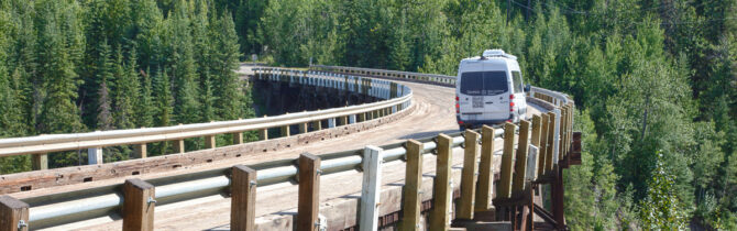
Today we drove a 7 mile section of the “old highway.” It certainly is more winding and narrower than what we travel on today. The Canadian Government is slowly relocating and/or improving the current highway so it is more suitable to today’s heavy truck traffic. The reason we went off on the old road was to see the Kiskatinaw River Bridge – a curved, 534-foot wooden structure built in 1942. It took as long to build (9 months) as did the entire AlCan highway. It is considered a treasure, but is now bypassed. All-in-all, over 300 bridges had to be constructed in 1942 for the highway. Most were like the utilitarian suspension bridge we crossed a few days ago over the Liard River – which is the only one of that type that remains.
After Fort St. John and Dawson Creek we began to see evidence of agriculture and logging. We passed huge fields of canola (rape seed) as well as hay and alfalfa. Lots of horses grazing and a few cattle.
Since we had a late afternoon start leaving Dawson Creek and encountered lots of traffic and construction, we stopped only about 40 miles out of the city in Hythe where they have a municipal campground. It’s basically a treed square with 24 sites around it. Dinner was homemade beef soup and bean salad.
Hyeth Municipal Campground Review: 24 adequate, but not wide back-in sites located on the perimeter of a treed field. Picnic tables and some fire rings. (The literature from the visitors’ center promises free firewood. None was evident.) 30-amp power at most sites. There are two old railroad cars on site that are used as the bathrooms (flush toilets). An RV dump and potable water are available. Noise from Route 2-43 is noticeable, but not annoying.
-- Janet (text) and David (photos)
Recent Comments