Alamo Lake SP
We moved from One state park to another. The drive was about 200 miles. After leaving Parker, we saw few homes or ranches. Near the town of Boise we saw a large feed plant that provides for a large egg laying operation. Near Vicksburg a lot of alfalfa is grown for feed for a large confined cattle operation.
After driving west we finally started north through the mountains to Alamo Lake SP. it’s a very long drive through nothing and we soon had no AT&T coverage so no google maps. But there were no turns so it wasn’t an issue.
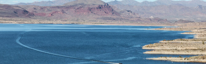
The campground is right in the edge of Alamo lake – created by an earthen dam built by the Army Corp of engineers to control flooding in the area and for recreation. We took a two-mile walk up into the hills which gave great views of the area. We heard and saw evidence of the wild burros that live here, but never saw one. We are here for a number of days so we will have other opportunities.
The A-B campground has primitive, electric/water, and electric/water/sewer sites. All have views of the lake and surrounding hills. There are three other camping areas, one, C, has electric sites. We can get a weak, slow AT&T signal with both boosters on. Signs on our walk indicated where on the hills one might get cell service!
-- Janet (text) and David (photos)
Recent Comments