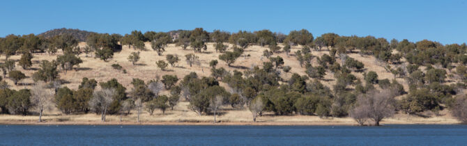
Parker Canyon Lake
Lakeview CG is a two-hour drive west and south of the Whitewater Draw, near the Mexico border. The drive starts out through shrubby, grassy flat land with mountains in the distance. At Sonoita we started south through incredible foothills covered with long golden grass studded with cattle and horses. As we climbed into the Coronado National Forest, the flora became oaks, juniper, and pine — not towering forests — perhaps 10-20 feet tall. The lake and campground are located at 5400 feet.
The campground here is very nice, but relatively primitive. Running water centrally located, no electric, fire rings, and picnic tables. There is no dump. Only Mexican cell data service and no English speaking TV over the air.
Our Sunday hike around the lake was lovely. The 5-6 mile path follows the perimeter of the lake so it is mostly flat. At times we walked through grassy fields, others oak and pine forest. About halfway around the lake we crossed the earthen dam that forms the lake, built in the 1960s.
On Monday when we headed north to our next stop, Kartchner Cavers again, we did encounter one difficulty. Google maps suggested a route using the Cimarron Road. It’s a fine road, perhaps smoother than 83, but it passes through the Fort Huachuca military reservation and one needs a pass to enter. Needless to say we did not have one. There are no markings on the turnoff from the main road. Be warned.
-- Janet (text) and David (photos)
Recent Comments