Dawson City I
We started our morning with a mile or so hike up one of the tundra-covered hills nearby. The tundra was even softer and squishier than that we had walked on in Denali NP. After a scramble up a granite and quartz outcropping, we were at a point higher than everything around us. We had a 360-degree view of the mountains around us. Wow!
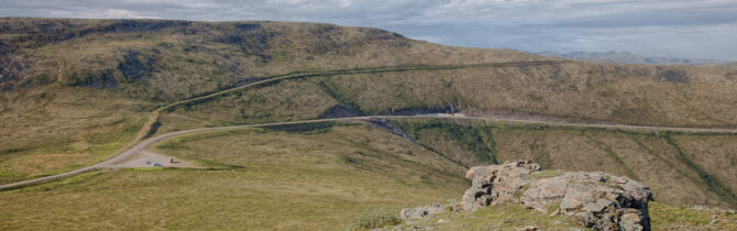
Then it was back to the gravel/chip seal/dirt/potholes of the Top of the World Highway. The highway is in pretty good shape. “Breaks” are marked with orange flags on the side of the road. It’s 60 miles of pretty much of the same thing, but it is hard to call it boring. Around each turn is another view of spruce and/or tundra covered mountains, streams deep down in the valleys, and our road snaking along the ridges. Unlike many roads this one does not follow the valleys. After climbing up to Chicken and Eagle, we remained high on the ridges with little elevation change until we approached Dawson City. Thus the name “Top of the world highway”.
Dawson City is a city of about 2000 on the banks of the Yukon River. To reach it when arriving from the west, we had to take a ferry (free) across the Yukon. The ferry is basically an 83-foot barge moved by a tug. The crossing takes about 5 to 10 minutes with another 5 to 10 minutes for loading and unloading. We had an hour wait to be loaded (we ate our lunch during this time), partly because one of the vehicles also waiting was a huge fuel tanker which had to go alone. The current is swift and the river high after all this rain. It was not reassuring to see the tug fighting the current when weighted down with the tanker. If the engine had a problem, we would soon be miles downstream.
Dawson is quaint, clean, and inviting. The original nineteenth and early twentieth century buildings have been restored and are in use for stores, hotels and B&B’s, and restaurants. One is a fudge shop (why is it that every tourist destination sells fudge?) They have reconstructed Diamond Tooth Gertie’s Gambling Hall and now offer a gold rush revival floor show along with casino style gambling. We did not partake of most of the offerings, rather used the Wi-Fi at the visitors’ center while listening to a performance which was part of the annual Music Festival.
Soon it started to rain so we headed to a gas station for fuel and found a campsite at a YT campground. Salmon, salad, and beets for dinner.
One interesting traveler we saw today is a very rugged camper which is plated in Europe. I believe we may have also seen them down in Waterton Lakes in May. The outside of the vehicle says “Looking4adventure.de”. I’m hoping when I am on Wi-Fi to find a blog there about their adventure.
Klondike River Territorial Campground: 38 well-spaced, level, gravel sites. Pit toilets, picnic tables, and fire rings. Wood provided, but bring your axe; the wood is cut into logs 12-inches long but are 8 to 10-inches in diameter. $12 fee for the night.
-- Janet (text) and David (photos)
Recent Comments